
 Cetak Laman Ini
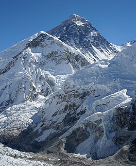
Mount Everest -- also called Mount Chomolungma in Tibetan and Sagarmāthā(Nepali: सगरमाथा) -- is the world's highest mountain at 8,848 metres (29,029 ft) abovesea level . Everest is in the Mahalangur section of the Himalaya on the Nepal-China(Tibet) border. Its massif includes neighboring peaks Lhotse (8516m), Nuptse (7855m), and Changtse (7580m).
In 1856, the Great Trigonometric Survey of British India established the first published height of Everest, then known as Peak XV, at 29,002 ft (8,840 m). In 1865, Everest was given its official English name by the Royal Geographical Society upon recommendation of Andrew Waugh, the British Surveyor General of India at the time, who named it after his predecessor in the post, and former chief, Sir George Everest. Chomolungma had been in common use by Tibetans for centuries, but Waugh was unable to propose an established local name because Nepal and Tibet were closed to foreigners.
 The highest mountain in the world attracts many well-experienced mountaineers as well as novice climbers who are willing to pay substantial sums to professional mountain guides to complete a successful climb. The mountain, while not posing substantial technical climbing difficulty on the standard route (other eight-thousanders such as K2 orNanga Parbat are much more difficult), still has many inherent dangers such as altitude sickness, weather, and wind.
By the end of the 2008 climbing season, there had been 4,102 ascents to the summit by about 2,700 individuals.[4] Climbers are a significant source of tourist revenue for Nepal, whose government also requires all prospective climbers to obtain an expensive permit, costing up to US$25,000 per person.[5] By the end of 2009 Everest had claimed 216 lives,[4] including eight who perished during a 1996 storm high on the mountain. Conditions are so difficult in the death zone (altitudes higher than 8,000 m/26,246 ft) that most corpses have been left where they fell. Some of them are visible from standard climbing routes.[6]
 In 1808, the British began the Great Trigonometric Survey of India to determine the location and names of the world's highest mountains. Starting in southern India, the survey teams moved northward using giant 500 kg (1,100 lb)theodolites (each requiring 12 men to carry) to measure heights as accurately as possible. They reached the Himalayan foothills by the 1830s, but Nepal was unwilling to allow the British to enter the country because of suspicions of political aggression and possible annexation. Several requests by the surveyors to enter Nepal were turned down.[7]
The British were forced to continue their observations from Terai, a region south of Nepal which is parallel to the Himalayas. Conditions in Terai were difficult owing to torrential rains and malaria—three survey officers died from malaria while two others had to retire owing to failing health.[7]
Nonetheless, in 1847, the British pressed on and began detailed observations of the Himalayan peaks from observation stations up to 240 km (150 mi) away. Weather restricted work to the last three months of the year. In November 1847, Andrew Waugh, the British Surveyor General of India made several observations from Sawajpore station located in the eastern end of the Himalayas. Kangchenjunga was then considered the highest peak in the world, and with interest he noted a peak beyond it, some 230 km (140 mi) away. John Armstrong, one of Waugh's officials, also saw the peak from a location further west and called it peak 'b'. Waugh would later write that the observations indicated that peak 'b' was higher than Kangchenjunga, but given the great distance of the observations, closer observations were required for verification. The following year, Waugh sent a survey official back to Terai to make closer observations of peak 'b', but clouds thwarted all attempts.[7]
In 1849, Waugh dispatched James Nicolson to the area. Nicolson made two observations from Jirol, 190 km (120 mi) away. Nicolson then took the largest theodolite and headed east, obtaining over 30 observations from five different locations, with the closest being 174 km (108 mi) away from the peak.[7]
Nicolson retreated to Patna on the Ganges to perform the necessary calculations based on his observations. His raw data gave an average height of 9,200 m (30,200 ft) for peak 'b', but this did not consider light refraction, which distorts heights. The number clearly indicated, however, that peak 'b' was higher than Kangchenjunga. However, Nicolson came down with malaria and was forced to return home, calculations unfinished. Michael Hennessy, one of Waugh's assistants, had begun designating peaks based on roman numerals, with Kangchenjunga named Peak IX, while peak 'b' now became known as Peak XV.[7]
In 1852, stationed at the survey's headquarters in Dehradun, Radhanath Sikdar, an Indian mathematician and surveyor from Bengal, was the first to identify Everest as the world's highest peak, using trigonometric calculations based on Nicolson's measurements.[8] An official announcement that Peak XV was the highest was delayed for several years as the calculations were repeatedly verified. Waugh began work on Nicolson's data in 1854, and along with his staff spent almost two years working on the calculations, having to deal with the problems of light refraction, barometric pressure, and temperature over the vast distances of the observations. Finally, in March 1856 he announced his findings in a letter to his deputy in Kolkata. Kangchenjunga was declared to be 28,156 ft (8,582 m), while Peak XV was given the height of 29,002 ft (8,840 m). Waugh concluded that Peak XV was "most probably the highest in the world".[7] Peak XV (measured in feet) was calculated to be exactly 29,000 ft (8,839.2 m) high, but was publicly declared to be 29,002 ft (8,839.8 m). The arbitrary addition of 2 ft (61 cm) was to avoid the impression that an exact height of 29,000 feet (8,839.2 m) was nothing more than a rounded estimate.[9]
With the height now established, what to name the peak was clearly the next challenge. While the survey was anxious to preserve local names if possible (e.g. Kangchenjunga and Dhaulagiri), Waugh argued that he could not find any commonly used local name. Waugh's search for a local name was hampered by Nepal and Tibet's exclusion of foreigners. Many local names existed, with perhaps the best known in Tibet for several centuries being Chomolungma, which had appeared on a 1733 map published in Paris by the French geographer D'Anville. However, Waugh argued that with the plethora of local names, it would be difficult to favour one name over all others. So, he decided that Peak XV should be named after George Everest, his predecessor as Surveyor General of India.[7][10] He wrote:
I was taught by my respected chief and predecessor, Colonel Sir George Everest to assign to every geographical object its true local or native appellation. But here is a mountain, most probably the highest in the world, without any local name that we can discover, whose native appellation, if it has any, will not very likely be ascertained before we are allowed to penetrate into Nepal. In the meantime the privilege as well as the duty devolves on me to assign...a name whereby it may be known among citizens and geographers and become a household word among civilized nations.[11]
George Everest opposed the name suggested by Waugh and told the Royal Geographical Society in 1857 that Everest could not be written inHindi nor pronounced by "the native of India". Waugh's proposed name prevailed despite the objections, and in 1865, the Royal Geographical Society officially adopted Mount Everest as the name for the highest mountain in the world.[7] Interestingly, the modern pronunciation of Everest English pronunciation: /ˈɛvərɨst, ˈɛvrɨst/[12] is in fact different from Sir George's pronunciation of his surname, which was /ˈiːvrɨst/.[13]
The Tibetan name for Mount Everest is Chomolungma or Qomolangma
In the late 19th century, many European cartographers incorrectly believed that a native name for the mountain was Gaurisankar.[15] This was a result of confusion of Mount Everest with Gauri Sankar, which, when viewed from Kathmandu, stands almost directly in front of Everest.[citation needed]
In the early 1960s, the Nepalese government gave Mount Everest the official name Sagarmāthā (सगरमाथा).[16] This name had not previously been used; the local inhabitants knew the mountain as Chomolungma. The mountain was not known and named in ethnic Nepal (that is, theKathmandu valley and surrounding areas).[citation needed] The government set out to find a Nepalese name for the mountain because theSherpa/Tibetan name Chomolungma was not acceptable, as it would have been against unification (Nepalization) of the country.[citation needed]
In 2002, the Chinese People's Daily newspaper published an article making a case against the continued use of the English name for the mountain in the Western world, insisting that it should be referred to by its Tibetan name. The newspaper argued that the Chinese use of the Tibetan name preceded the English one, as Mount Qomolangma was marked on a Chinese map more than 280 years ago.[17]
In 1856, Andrew Waugh announced Everest (then known as Peak XV) as 29,002 ft (8,840 m) high, after several years of calculations based on observations made by the Great Trigonometric Survey.
The 8,848 m (29,029 ft) height given in this article is officially recognised by Nepal and China.[18]On 9 October 2005, after several months of measurement and calculation, the Chinese Academy of Sciences and State Bureau of Surveying and Mapping officially announced the height of Everest as 8,844.43 m (29,017.16 ft) with accuracy of ±0.21 m (0.69 ft). They claimed it was the most accurate and precise measurement to date.[19] This height is based on the actual highest point of rock and not on the snow and ice covering it. The Chinese team also measured a snow/ice depth of 3.5 m (11 ft),[20] which is in agreement with a net elevation of 8,848 m (29,029 ft). The snow and ice thickness varies over time, making a definitive height of the snow cap impossible to determine.
The elevation of 8,848 m (29,029 ft) was first determined by an Indian survey in 1955, made closer to the mountain, also using theodolites.[citation needed] It was subsequently reaffirmed by a 1975 Chinese measurement 8,848.13 m (29,029.30 ft).[20] In both cases the snow cap, not the rock head, was measured. In May 1999 an American Everest Expedition, directed by Bradford Washburn, anchored a GPS unit into the highest bedrock. A rock head elevation of 8,850 m (29,035 ft), and a snow/ice elevation 1 m (3 ft) higher, were obtained via this device.[21] Although it has not been officially recognized by Nepal,[22] this figure is widely quoted. Geoid uncertainty casts doubt upon the accuracy claimed by both the 1999 and 2005 surveys.
A detailed photogrammetric map (at a scale of 1:50,000) of the Khumbu region, including the south side of Mount Everest, was made by Erwin Schneider as part of the 1955 International Himalayan Expedition, which also attempted Lhotse. An even more detailed topographicmap of the Everest area was made in the late 1980s under the direction of Bradford Washburn, using extensive aerial photography.[23]
It is thought that the plate tectonics of the area are adding to the height and moving the summit northeastwards. Two accounts suggest the rates of change are 4 mm (0.16 in) per year (upwards) and 3 to 6 mm (0.12 to 0.24 in) per year (northeastwards),[21][24] but another account mentions more lateral movement (27 mm/1.1 in),[25] and even shrinkage has been suggested.[26]
The summit of Everest is the point at which the Earth's surface reaches the greatest distance above sea level. Several other mountains are sometimes claimed as alternative "tallest mountains on Earth". Mauna Kea in Hawaii is tallest when measured from its base;[27] it rises over 10,200 m (6.3 mi) when measured from its base on the mid-ocean floor, but only attains 4,205 m (13,796 ft) above sea level.
By the same measure of base[27] to summit, Mount McKinley, in Alaska, is also taller than Everest. Despite its height above sea level of only 6,193.6 m (20,320 ft), Mount McKinley sits atop a sloping plain with elevations from 300 m (980 ft) to 900 m (3,000 ft), yielding a height above base in the range of 5,300 to 5,900 m (17,400 to 19,400 ft); a commonly quoted figure is 5,600 m (18,400 ft).[28] By comparison, reasonable base elevations for Everest range from 4,200 m (13,800 ft) on the south side to 5,200 m (17,100 ft) on the Tibetan Plateau, yielding a height above base in the range of 3,650 to 4,650 m (11,980 to 15,260 ft).[23]
The summit of Chimborazo in Ecuador is 2,168 m (7,113 ft) farther from the Earth's centre (6,384.4 km (3,967.1 mi)) than that of Everest (6,382.3 km (3,965.8 mi)), because the Earth bulges at the Equator. However, Chimborazo attains a height of only 6,267 m (20,561 ft) above sea level, and by this criterion it is not even the highest peak of the Andes.
Tidak ada komentar:
Posting Komentar