
 Cetak Laman Ini
The Grand Canyon is a steep-sided canyon carved by the Colorado River in the United States in the state of Arizona. It is largely contained within the Grand Canyon National Park, one of the first national parks in the United States. President Theodore Roosevelt was a major proponent of preservation of the Grand Canyon area, and visited it on numerous occasions to hunt and enjoy the scenery.
The Grand Canyon is 277 miles (446 km) long, up to 18 miles (29 km) wide and attains a depth of over a mile (6,000 feet / 1,800 metres)[1] Nearly two billion years of the Earth's geological history have been exposed as the Colorado River and its tributaries cut theirchannels through layer after layer of rock while the Colorado Plateau was uplifted.[2] While the specific geologic processes and timing that formed the Grand Canyon are the subject of debate by geologists,[3] recent evidence suggests the Colorado River established its course through the canyon at least 17 million years ago.[4][5] Since that time, the Colorado River continued to erode and form the canyon to its present-day configuration.[6]
Before European immigration, the area was inhabited by Native Americans who built settlements within the canyon and its many caves. The Pueblo people considered the Grand Canyon ("Ongtupqa" in Hopi language) a holy site and made pilgrimages to it.[7] The first European known to have viewed the Grand Canyon was García López de Cárdenas from Spain, who arrived in 1540.[8]
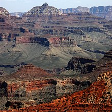
The Grand Canyon is a huge rift in the Colorado Plateau that exposes uplifted Proterozoic andPaleozoic strata, and is also one of the 19 distinct physiographic sections of the Colorado Plateau province. It is not the deepest canyon in the world (Kali Gandaki Gorge in Nepal is far deeper), nor the widest (Capertee Valley in Australia is about 0.6 mi/1 km wider and longer than Grand Canyon); however, the Grand Canyon is known for its visually overwhelming size and its intricate and colorful landscape. Geologically it is significant because of the thick sequence of ancient rocks that are beautifully preserved and exposed in the walls of the canyon. These rock layers record much of the early geologic history of the North American continent.
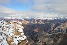
Uplift associated with mountain formation later moved these sediments thousands of feet upward and created the Colorado Plateau. The higherelevation has also resulted in greater precipitation in the Colorado River drainage area, but not enough to change the Grand Canyon area from being semi-arid. The uplift of the Colorado Plateau is uneven, and the Kaibab Plateau that Grand Canyon bisects is over a thousand feet higher at the North Rim (about 1,000 ft/300 m) than at the South Rim. Almost all runoff from the North Rim (which also gets more rain and snow) flows toward the Grand Canyon, while much of the runoff on the plateau behind the South Rim flows away from the canyon (following the general tilt). The result is deeper and longer tributary washes and canyons on the north side and shorter and steeper side canyons on the south side.
Temperatures on the North Rim are generally lower than the South Rim because of the greater elevation (averaging 8,000 ft/2,438 m above sea level).[9] Heavy rains are common on both rims during the summer months. Access to the North Rim via the primary route leading to the canyon (State Route 67) is limited during the winter season due to road closures. Views from the North Rim tend to give a better impression of the expanse of the canyon than those from the South Rim.
The Colorado River basin (of which the Grand Canyon is a part) has developed in the past 40 million years. A recent study places the origins of the canyon beginning some 17 million years ago. Previous estimates had placed the age of the canyon at 5 to 6 million years. The study, which was published in the journal Science in 2008, used uranium-lead dating to analyze calcite deposits found on the walls of nine caves throughout the canyon.[10] There is a substantial amount of controversy because this research suggests such a substantial departure from prior widely supported scientific consensus.[11]
The result of all this erosion is one of the most complete geologic columns on the planet.
The major geologic exposures in the Grand Canyon range in age from the 2 billion year old Vishnu Schist at the bottom of the Inner Gorge to the 230 million year oldKaibab Limestone on the Rim. There is a gap of about one billion years between the stratum that is about 500 million years old and the lower level, which is about 1.5 billion years old. This large unconformity indicates a period of erosion between two periods of deposition.
Many of the formations were deposited in warm shallow seas, near-shore environments (such as beaches), and swamps as the seashore repeatedly advanced and retreated over the edge of a proto-North America. Major exceptions include the Permian Coconino Sandstone, which contains abundant geological evidence ofaeolian sand dune deposition. Several parts of the Supai Group also were deposited in non–marine environments.
The great depth of the Grand Canyon and especially the height of its strata (most of which formed below sea level) can be attributed to 5,000 to 10,000 feet (1500 to 3000 m) of uplift of the Colorado Plateau, starting about 65 million years ago (during the Laramide Orogeny). This uplift has steepened the stream gradient of the Colorado River and its tributaries, which in turn has increased their speed and thus their ability to cut through rock (see the elevation summary of the Colorado River for present conditions).
Weather conditions during the ice ages also increased the amount of water in the Colorado River drainage system. The ancestral Colorado River responded by cutting its channel faster and deeper.
The base level and course of the Colorado River (or its ancestral equivalent) changed 5.3 million years ago when the Gulf of California opened and lowered the river's base level (its lowest point). This increased the rate of erosion and cut nearly all of the Grand Canyon's current depth by 1.2 million years ago. The terraced walls of the canyon were created by differential erosion.[12]
Tidak ada komentar:
Posting Komentar